KaLi Pegmatite Project
Overview
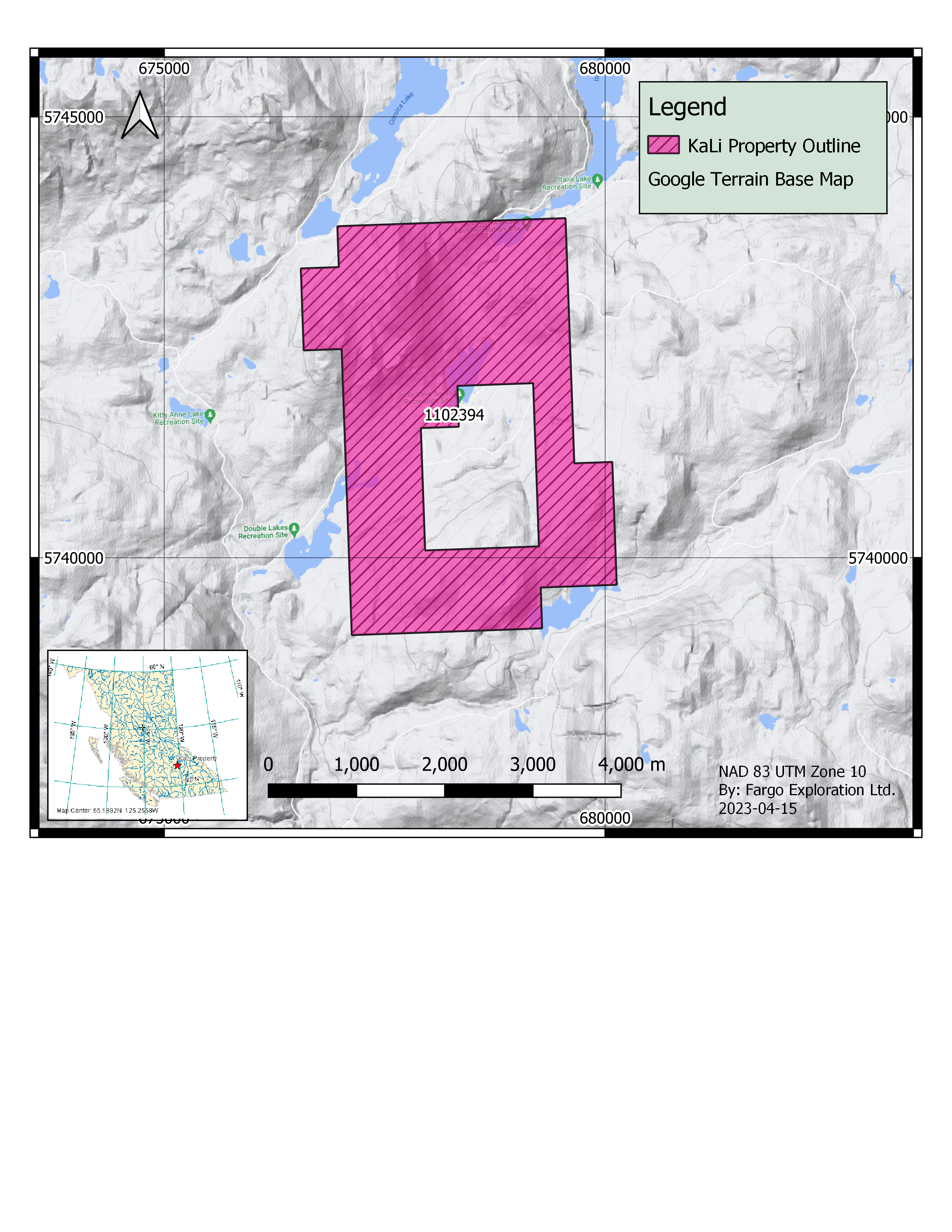
The KaLi Pegmatite Project is located approximately 30 km North-West of Clearwater, BC. in the South Cariboo region of central British Columbia, Canada. The property is made up of one mineral tenure totaling 1059.53 hectares. This property is owned 100% by Green River Gold Corp.
Project Highlights
The KaLi Pegmatite Project has an appreciable amount of historical data dating back to the 1960’s that our team has been reviewing and interpreting. During this review our team has identified records that this property is host to pegmatites and upon further study may have the potential to contain lithium.
Property Geological Setting
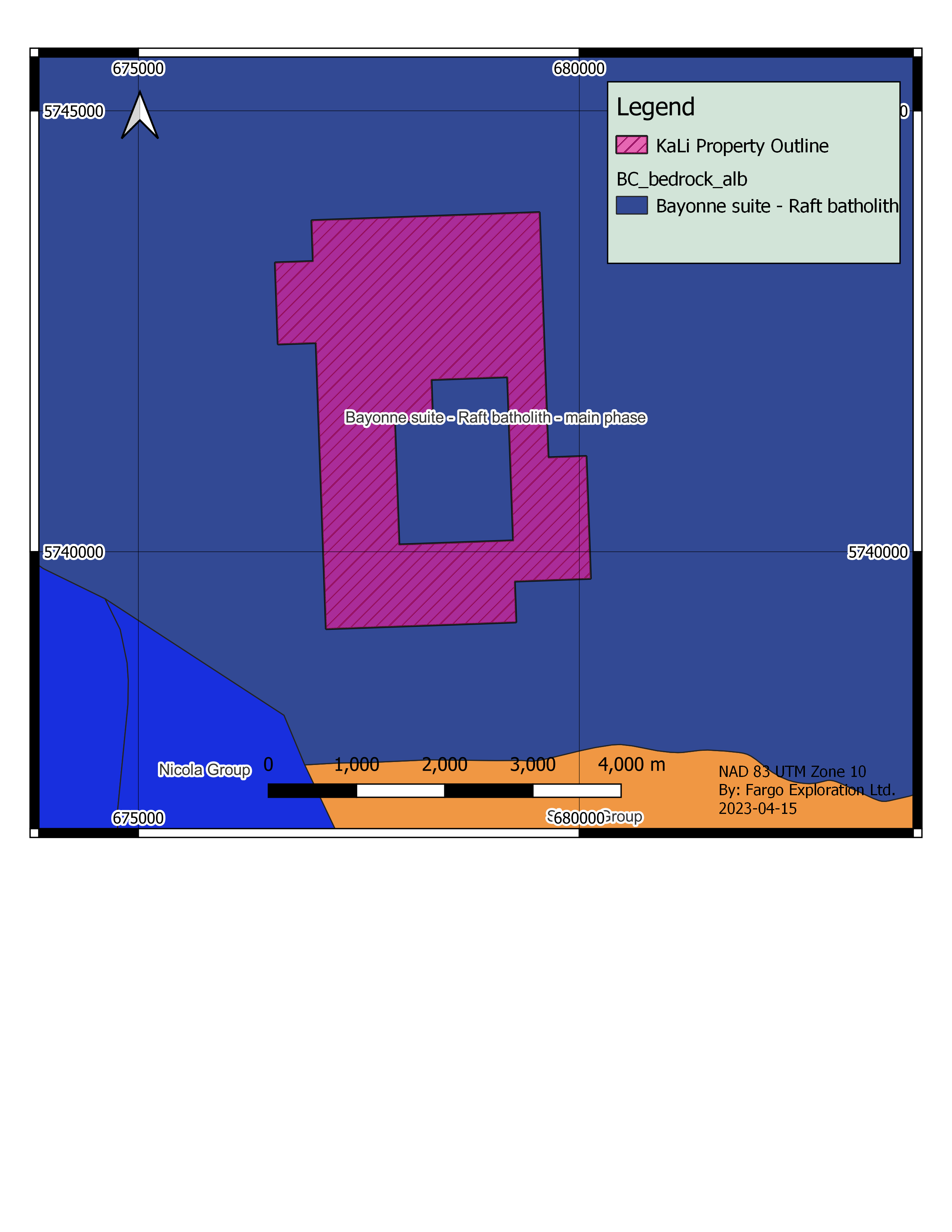
The KaLi Pegmatite Project occurs within the Shushwap Highlands which forms the southeastern portion of the Interior Plateau Division of the Canadian Cordillera (S.S. Holland 1964; pp. 73-74).
The whole property lies between 1350 and 1700-meters elevations above sea level.
The only stream of significance on the property is Patricia Creek. It flows south to Coldsaur Lake which in turn empties southeast through Mann Creek into the North Thompson River. It is an area of moderate relief and round-topped ridges.

Project History
The KaLi Pegmatite Project dates back to the early 1960’s when Noranda Exploration conducted the first comprehensive soil Geochem survey over an approximate 5.0 km by 1.5 km wide area. This was followed by two other grassroots surveys conducted by Amoco in 1974 and Norseman Mining Corp. in 1980 who further duplicated the geochemistry. In 1981 Placer Development Ltd. performed geochemical and geophysical survey near the south-western extent of the property. With the primary focus of exploration in this area over the last 6 decades being focused on Molybdenum, it is the author’s belief that the potential for LCT Pegmatites in the area was overlooked by all previous prospecting.
Past Exploration
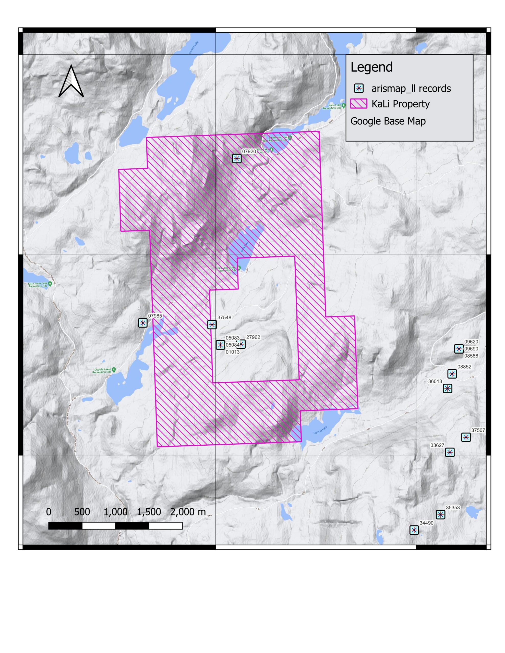
- 1966 Noranda Exploration conducted a soil survey for molybdenum on the Mad and Nord claims. Results indicated an anomalous area about 14,000 feet by 7,000 feet, containing a smaller (2,000 feet by 2,000 feet) much more anomalous high area with values up to 300ppm. Some minor amounts of molybdenite were found by prospecting but this was interrupted by winter. (Aris report 01013)
- In 1966 and 1967 Falconbridge Nickel Mines conducted a geochemical survey over the Wet, Sun and Aku claims. 3443 B-horizon samples were taken at 200’ intervals on pace and compass lines totaling 144 miles in length. Anomalous molybdenum values occurred over an area of approximately 4 square miles. The large areal extent and number of high values appeared to have indicated a zone worthy of further detailed sampling and mapping. No definitive conclusions could be drawn pending further detailed development. (Aris report 01026)
- In 1967 Anaconda American Brass Ltd. conducted a geochemical survey over the CL claims. Lines were cut within the claim area and soil samples were taken at 100-foot intervals. The survey indicated that anomalous values of molybdenum are present, but whose significance remains to be determined. (Aris report 01092)
- In 1968 Anaconda American Brass Ltd. conducted an Induced Polarization survey on the CL claims. The I.P. survey indicated several areas of weak “metallic” mineral concentration. (Aris report 01664)
- In 1969 Anaconda American Brass Ltd. conducted another Induced Polarization survey, this time on the S.L. claim group. No strong anomalies were recorded, however, readings above 30 minutes were weakly anomalous. (Aris report 02433)
- In 1970 Canadian Superior Exploration conducted a Ground Magnetometer Survey on the CS claim group. It was postulated that molybdenite mineralization could be associated with hydrothermal destruction of magnetite and hence magnetic lows. Three such areas were located. (Aris report 02571)
- In 1974 Amoco Canada Petroleum Company completed a geochemical survey on the Wap claims. The geochemical results indicated the presence of a definite area anomalous in molybdenum. (Aris report 05083)
- In 1974 Amoco Canada Petroleum Company also completed 77.6 miles of line cutting to facilitate the previously mentioned geochemical survey. (Aris report 05084)
- In 1973 Amoco Canada Petroleum Company conducted a magnetometer survey on the Wap Claims. Geochemistry of soils, silt sand rocks outlined a composite molybdenum-copper-silver-zinc anomaly 5,000 feet long and 2,000 feet wide. The ground magnetometer survey could not be interpreted reliably. (Aris report 05085)
- During the early part of August 1976, an induced polarization survey was conducted on the Cosa and Nostra claims on behalf of Vital Mines Ltd. The survey detected a moderately anomalous chargeability response which could be caused by some 2-6% by volume of sulfide mineralization and is there for worthy of further investigation. (Aris report 06171)
- In 1979 Norsemont Mining Corporation completed extensive work on the KD, KM and Moly claims comprised of road work, soil sampling, geological survey, trenching and percussion drilling. The work on the Moly claim group has confirmed the presence of molybdenum and copper in the pegmatitic phase of the Baldy Intrusion. There is evidence suggesting that the molybdenite has been partially leached. To date only a minor portion of the anomalous molybdenum areas on the claim group have been tested. It is necessary to sample and to test all of the anomalous molybdenum areas in order to determine if there is an economic deposit of molybdenum and/or copper. (Aris report 07920)
- In 1980 Placer Development Ltd. conducted a magnetic survey on the DD claim group. Porphyry-type molybdenum mineralization occurring in quartz veins is found in an area roughly one km in diameter lying roughly 1.5 km east-northeast of Patricia Lake. Upon first inspection of the data there would appear to be a definite magnetic pattern suggestive of a “porphyry-type” alteration halo-magnetic low. The only large magnetic low appears to arc from the west central through the north and into the east central portion of the grid. This broad magnetic “low” partially surrounds an area of higher values and is itself bounded to the south, west and east by higher magnetic values. (Aris report 07985)
- In 1980 Bethlehem Copper conducted a geochemical survey. A total of 1137 stream silt and soil samples were collected on the PL claims. Several of the east-west claim lines were used as baselines to establish a sampling grid. The lines were 400 meters apart, and sample spacing was 200 meters, with more closely spaced lines in the geochemically anomalous area. Several phases of intrusive rocks exist on the PL claims. Aplite dykes up to 20 centimeters thick are common, and quartz-feldspar pegmatites are fairly common. The main intrusive body consists primarily of an equigranular granodiorite with fresh biotite and feldspar crystals. Grain size generally decreases from west to east, while chloritization of the mafic minerals increases. A quartz porphyry of limited extent outcrops in the canyon in PL 1 and PL 3, 1,200 meters east of the north-south claim line. (Aris Report 08588)
- In 1981 Placer Development Limited conducted a short exploration program over the D.D. Claim Group. The program consisted of geochemical sampling, geophysical surveying, geological mapping and supportive grid work. (Aris report 08852)
- In 1980, Sable Resources conducted geophysical and geochemical surveys over the DL claim group. Work carried out during 1980 consisted of laying out approximately 35 km. of chain sawed grid. Lines were run north-south at roughly 500-meter intervals with stations every 50 meters. Soil samples were collected over the entire grid and analyzed for molybdenum. A magnetometer survey was carried out over the grid area with readings being taken at 50-meter intervals on all lines. (Aris report 09019a and 09019b)
- In 1981, Cominco Ltd. performed a geophysical survey over the Patricia Lake Property. During the period August 7-18, 1981, a Cominco geophysical crew completed an induced polarization survey on portions of the Patricia Lake property. A total of24 line kilometers on 8 lines 200 meters apart were surveyed using the pole dipole electrode array, with an electrode spacing of 50 meters and separations of 1, 2, and 3. (Aris report 09260)
- In 1981 Cominco Ltd. also completed a geological and geochemical report on the PL claims. Detailed geological mapping was undertaken in 1981 in two areas of PL 1, 2 and 3 where molybdenum was anomalous in soils and in south central PL 3 where an Induced Polarization geophysical survey defined a strong chargeability high and resistivity low. Total area covered by mapping is approximately 3 square kilometers at a scale of 1:10,000. One 2m x 1m x 3m trench was excavated in north central PL 3. Soil, stream sediment and rock chip sampling accompanied the mapping and trenching. (Aris report 09690)
- In 2005, Bryan Livgard performed soil and silt sampling on the Bry claims. Work in 2005, consisting of soil and silt surveys, although small pointed to potential mineralized areas. (Aris report 27962)
- In 2013, DGW Consultants performed a geophysical survey on the Aku Project. In September 2013 DGW Consultants completed a reconnaissance geophysical survey program on their AKU property. The mandate of the program was to carry out a total magnetic field survey over the property to aid in the geological interpretation of this area.
The geophysical survey was successful in collecting 5.15-line km’s of ground magnetic data covering an area of ~1.5km2 on the AKU property. When the magnetic data was compared to the soil geochemical survey carried out in 2012 a good correlation between mag-lows and Mo-in-soil anomalies was identified. (Aris report 34490)
- In 2017-2018, A.R. Pollmer conducted a limited diamond drilling program on the Mahood Moly Property. The 2018 drilling failed to find a sufficient frequency of quartz, K-spar veins hosting molybdenum or disseminated mineralization. There were three dominant fracture orientations, 450, 700, 200, listed in order of abundance. The veins dipping at 450 to the core hosted most of the visible Mo, which conforms with the surface vein exposures which dip vertically. Drill holes M17-01 & M17-02 intersected alteration and it would have been helpful if these holes could have continued downward.
The limited dispersion and shallow nature of the 3 drill holes, set within a 1,000m by 300m wide target area, is realized to be inadequate coverage. However, two holes did intersect molybdenum bearing veins. In summation the 2017 drill program is considered as inconclusive.(Aris report 37548)
- In 2021, A.R. Pollmer performed geological mapping and a geochemical survey of the Mahood Moly Property. The 2021 geological survey focused mainly on the area bedrock characteristics within the homogenous, coarse grained, monzonite which is part of the Raft Batholith. Mapping failed to find much in the way molybdenite mineral or mineralization indicators. One exception, located in the northern area at Waypoint #22, a bedrock containing a small amount of disseminated Molybdenum was found. (Aris report 39546)
Project Gallery